Tập tin gốc (4.000×4.000 điểm ảnh, kích thước tập tin: 1,48 MB, kiểu MIME: image/jpeg)

Miêu tả

Miêu tả

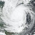
Typhoon Xangsane formed on September 25, 2006, in the western Pacific near the coast of the Philippine Islands. Over the next 36 hours, it grew from a tropical depression (area of low air pressure) to a typhoon. The typhoon crossed the Philippines and was credited for causing 76 deaths there before crossing the South China Sea and coming ashore in central Vietnam on October 1, according to the Agence France-Presse news service. As the storm came ashore in central Vietnam, it packed winds of 148 kilometers per hour (92 miles per hour), causing another six deaths and many injuries. Vietnamese authorities called Typhoon Xangsane the biggest storm to hit the country in several decades.

This photo-like image was acquired by the Moderate Resolution Imaging Spectroradiometer (MODIS) on the Terra satellite on October 1, 2006, at 10:10 a.m. local time (03:10 UTC). Xangsane at the time of this image was a well-defined spiral of clouds, but other typhoon characteristics were not obvious. It lacked a well-defined eye, and the spiral arms of the storm did not have sharp edges or evidence of strong thunderstorms. Much of the initial power of the storm had apparently been sapped as the typhoon came over land.
Ngày
Nguồn gốc NASA Earth Observatory Natural Hazards: Typhoon Xangsane
Tác giả NASA image created by Jesse Allen, Earth Observatory, using data provided courtesy of the MODIS Rapid Response team.
Giấy phép
(Dùng lại tập tin)
Public domain This file is in the public domain in the United States because it was solely created by NASA. NASA copyright policy states that "NASA material is not protected by copyright unless noted". (See Template:PD-USGov, NASA copyright policy page or JPL Image Use Policy.)
Warnings:

Chú thích

Ghi một dòng giải thích những gì có trong tập tin này

Khoản mục được tả trong tập tin này

mô tả

Lịch sử tập tin

Nhấn vào ngày/giờ để xem nội dung tập tin tại thời điểm đó.

Ngày/giờHình xem trướcKích cỡThành viênMiêu tả
hiện tại15:37, ngày 9 tháng 10 năm 2006Hình xem trước của phiên bản lúc 15:37, ngày 9 tháng 10 năm 20064.000×4.000 (1,48 MB)Nilfanionfix progressive jpg (right file this time..)
05:50, ngày 8 tháng 10 năm 2006Hình xem trước của phiên bản lúc 05:50, ngày 8 tháng 10 năm 20064.000×4.000 (2,98 MB)Coredesat{{Information |Description=NASA MODIS image of Typhoon Xangsane shortly after landfall in Vietnam on October 1, 2006. |Source=[http://earthobservatory.nasa.gov/NaturalHazards/natural_hazards_v2.php3?img_id=13913 NASA Earth Observatory Natural Hazards: Typ
Có 1 trang tại Wikipedia tiếng Việt có liên kết đến tập tin (không hiển thị trang ở các dự án khác):

Sử dụng tập tin toàn cục

Những wiki sau đang sử dụng tập tin này:

Đặc tính hình