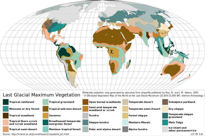
Tập tin:Last Glacial Maximum Vegetation Map.svg

Kích thước bản xem trước PNG này của tập tin SVG: 800×533 điểm ảnh. Độ phân giải khác: 320×213 điểm ảnh | 640×427 điểm ảnh | 1.024×683 điểm ảnh | 1.280×853 điểm ảnh | 2.560×1.707 điểm ảnh | 1.200×800 điểm ảnh.
Tập tin gốc (tập tin SVG, 1.200×800 điểm ảnh trên danh nghĩa, kích thước: 316 kB)
Tập tin này từ Wikimedia Commons. Trang miêu tả nó ở đấy được sao chép dưới đây. Commons là kho lưu trữ tập tin phương tiện có giấy phép tự do. Bạn có thể tham gia. |
Miêu tả
| Miêu tả |
Español: Mapa de la vegetación durante el Último Máximo Glacial hace ~18.000 años atrás. English: Reconstructed vegetation cover at the Last Glacial Maximum period ~18,000 years ago, describing the type of vegetation cover present, based on fossil pollen samples recovered from lake and bog sediments. |
| Ngày | |
| Nguồn gốc |
Map generated from shapefile published by Ray, N. and J. M. Adams. 2001, “ A GIS-based Vegetation Map of the World at the Last Glacial Maximum (25,000-15,000 BP). Internet Archaeology 11. ” Source: http://intarch.ac.uk/journal/issue11/rayadams_toc.html |
| Tác giả | Locoluis |
| English | Spanish |
|---|---|
| Tropical rainforest | Selva tropical |
| Monsoon or dry forest | Monzón o bosque seco |
| Tropical woodland | Sabana arbolada tropical |
| Tropical thorn scrub and scrub woodland | Matorral espinoso tropical y bosque de matorral |
| Tropical semi-desert | Semi-desierto tropical |
| Tropical grassland | Pradera tropical |
| Tropical extreme desert | Desierto extremo tropical |
| Savanna | Sabana |
| Broadleaved temperate evergreen forest | Bosque siempreverde templado de hojas anchas |
| Montane tropical forest | Bosque tropical montano |
| Open boreal woodlands | Bosque boreal abierto |
| Semi-arid temperate woodland or scrub | Sabana arbolada o matorral templado semi-árido |
| Tundra | Tundra |
| Steppe-tundra | Estepa-tundra |
| Polar and alpine desert | Desierto polar y alpino |
| Temperate desert | Desierto templado |
| Temperate semi-desert | Semi-desierto templado |
| Forest steppe | Bosque estepa |
| Montane mosaic | Mosaico montano |
| Alpine tundra | Tundra alpina |
| Subalpine parkland | Zona verde subalpina |
| Dry steppe | Estepa seca |
| Temperate steppe grassland | Pastizal de estepa templada |
| Main Taiga | Taiga principal |
| Ice sheet and other permanent ice | Campos de hielo y otro hielos permanentes |
Giấy phép
Tập tin này được phát hành theo Giấy phép Creative Commons Ghi công 3.0 Chưa chuyển đổi
- Bạn được phép:
- chia sẻ – sao chép, phân phối và chuyển giao tác phẩm
- pha trộn – để chuyển thể tác phẩm
- Theo các điều kiện sau:
- ghi công – Bạn phải ghi lại tác giả và nguồn, liên kết đến giấy phép, và các thay đổi đã được thực hiện, nếu có. Bạn có thể làm các điều trên bằng bất kỳ cách hợp lý nào, miễn sao không ám chỉ rằng người cho giấy phép ủng hộ bạn hay việc sử dụng của bạn.
Lịch sử tập tin
Nhấn vào ngày/giờ để xem nội dung tập tin tại thời điểm đó.
| Ngày/giờ | Hình xem trước | Kích cỡ | Thành viên | Miêu tả | |
|---|---|---|---|---|---|
| hiện tại | 02:12, ngày 23 tháng 8 năm 2015 | | 1.200×800 (316 kB) | Locoluis | Minor font adjustments. Typo in original source. |
| 02:01, ngày 23 tháng 8 năm 2015 |  | 1.200×800 (316 kB) | Locoluis | User created page with UploadWizard |
Trang sử dụng tập tin
Có 1 trang tại Wikipedia tiếng Việt có liên kết đến tập tin (không hiển thị trang ở các dự án khác):
Sử dụng tập tin toàn cục
Những wiki sau đang sử dụng tập tin này:
- Trang sử dụng tại als.wikipedia.org
- Trang sử dụng tại ar.wikipedia.org
- Trang sử dụng tại bcl.wikipedia.org
- Trang sử dụng tại be.wikipedia.org
- Trang sử dụng tại ca.wikipedia.org
- Trang sử dụng tại cs.wikipedia.org
- Trang sử dụng tại da.wikipedia.org
- Trang sử dụng tại de.wikipedia.org
- Trang sử dụng tại el.wikipedia.org
- Trang sử dụng tại en.wikipedia.org
- Trang sử dụng tại es.wikipedia.org
- Trang sử dụng tại fr.wikipedia.org
- Trang sử dụng tại fy.wikipedia.org
- Trang sử dụng tại ga.wikipedia.org
- Trang sử dụng tại hy.wikipedia.org
- Trang sử dụng tại it.wikipedia.org
- Trang sử dụng tại ja.wikipedia.org
- Trang sử dụng tại la.wikipedia.org
Xem thêm các trang toàn cục sử dụng tập tin này.