Tập tin:Indian Mysore Kingdom 1784 map.svg

Tập tin gốc (tập tin SVG, 1.639×1.852 điểm ảnh trên danh nghĩa, kích thước: 476 kB)

Tiêu đề
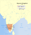
The Mysore Kingdom c1784
Lời miêu tả

Map showing the extent of the Mysore Kingdom under Tipu Sultan including the Keladi Kingdom.

 
Extent of Mysore Kingdom including Keladi, c1780
Map legend
Ngày
Nguồn gốc

Tác phẩm được tạo bởi người tải lên
International Borders: University of Texas map library - India Political map 2001
Disputed Borders: University of Texas map library - China-India Borders - Eastern Sector 1988 & Western Sector 1988 - Kashmir Region 2004 - Kashmir Maps.
State and District boundaries: Census of India - 2001 Census State Maps - Survey of India Maps.
Other sources: US Army Map Service, Survey of India Map Explorer, Columbia University

Map specific sources: "Suryanath U. Kamat, A Concise history of Karnataka from pre-historic times to the present, Jupiter books, MCC, Bangalore, 2001 (Reprinted 2002) OCLC: 7796041" Page 330.
Sáng tác
This Image was created by User:PlaneMad.
  • If you are using the image under the creative commons share alike license please credit the photo CC-by-sa PlaneMad/Wikimedia and include a link to this page. No explicit permission is needed from me, but id appreciate an email if my work has been of help to you.
  • If you dont want to release your work under a creative commons license, please mail me at arun.planemad@gmail.com or catch me at my Website to negotiate a custom license as per your needs.
Giấy phép
(Dùng lại tập tin)
Tôi, người giữ bản quyền tác phẩm này, từ đây phát hành nó theo giấy phép sau:
w:vi:Creative Commons
ghi công chia sẻ tương tự
Tập tin này được phát hành theo Giấy phép Creative Commons Ghi công - Chia sẻ tương tự 3.0 Chưa chuyển đồi
Bạn được phép:
  • chia sẻ – sao chép, phân phối và chuyển giao tác phẩm
  • pha trộn – để chuyển thể tác phẩm
Theo các điều kiện sau:
  • ghi công – Bạn phải ghi lại tác giả và nguồn, liên kết đến giấy phép, và các thay đổi đã được thực hiện, nếu có. Bạn có thể làm các điều trên bằng bất kỳ cách hợp lý nào, miễn sao không ám chỉ rằng người cho giấy phép ủng hộ bạn hay việc sử dụng của bạn.
  • chia sẻ tương tự – Nếu bạn biến tấu, biến đổi, hoặc tạo tác phẩm mới dựa trên tác phẩm này, bạn chỉ được phép phân phối tác phẩm mới theo giấy phép y hệt hoặc tương thích với tác phẩm gốc.

The frontiers depicted on the Indian maps in Wikipedia are from a neutral point of view and may differ from official government maps of India, Pakistan and China. Please consult local laws governing publication of maps before usage.
 Geotemporal data
Ngày mô tả nửa cuối năm thế kỷ 20 và thế kỷ 21
Spatial reference system conic
Bounding box
38°04′N 64°13′E / 38.06°N 64.21°E / 38.06; 64.21 38°34′N 100°03′E / 38.57°N 100.05°E / 38.57; 100.05
5°07′N 68°26′E / 5.12°N 68.44°E / 5.12; 68.44 5°36′N 96°52′E / 5.60°N 96.87°E / 5.60; 96.87
Georeferencing Georeference the map in Wikimaps Warper If inappropriate please set warp_status = skip to hide.
 Archival data
Ghi chú Part of WikiProject India Maps


Notes

Depiction of India's borders

  • The territorial boundaries of India are shown as per the actual ground situation in accordance with international practices followed by the United Nations ([1], [2]) and the National Geographic Society ([3], [4])
  • This map is meant to be for illustrative purpose only and is not authenticated by official government sources. Please check the list of sources and references used to create the map for a measure of accuracy and verifiability.
  • The usage of these maps in India, Pakistan and China are governed by different laws that restrict depictions of boundaries other than what is officially recognized by the state. Please check local laws and modify the map accordingly before use.

Explanation of disputed boundaries

  • Boundary of Indian claim : The territory India claims is legally theirs, but the claim is disputed by China and Pakistan.
  • Line of Control/Line of Conflict : The de facto administrative boundary recognised by the international community. This UN ceasefire line is considered as a temporary solution to an ongoing conflict since the departure of the British Raj.

Borders of disputed regions

The depicted extent of the former territory of the British Indian Empire, succeeded by Republic of India, may not be accepted by few countries as legal due to ongoing border disputes:

  • The northern Himalayan region of the disputed territory Indian-administered Kashmir is claimed by India including (Pakistan-administered Kashmir) and the Chinese-occupied territory of (Ladakh plateau). Since 1972, it is divided between all three countries. See also Line of Control and Line of Actual Control.
  • Siachen glacier (shown white) is an actively contested region between India and Pakistan. Since 1984, the region is under Indian control.
  • The northeastern territory of Arunachal Pradesh is almost entirely claimed by China as part of its Tibetan territory.
  • Minor areas of eastern Kashmir's Ladakh division, Himachal Pradesh and Uttarakhand on the Chinese frontier are claimed by China. These areas are under Indian control.
  • A small area of Uttarakhand adjoining the Nepal border along the Sarda river is disputed between the two countries.

For a detailed map of all disputed regions in South Asia, see Image:India disputed areas map.svg

Internal borders

The borders of the state of Meghalaya, Assam and Arunachal Pradesh are shown as interpreted from the North-Eastern Areas (Reorganisation) Act, 1971, but has yet to be verified.

Territorial waters

The limit of the territorial waters of India extends to twelve nautical miles measured from the appropriate baseline. See this for more information.

Chú thích

Ghi một dòng giải thích những gì có trong tập tin này

Khoản mục được tả trong tập tin này

mô tả

Lịch sử tập tin

Nhấn vào ngày/giờ để xem nội dung tập tin tại thời điểm đó.

Ngày/giờHình xem trướcKích cỡThành viênMiêu tả
hiện tại07:54, ngày 12 tháng 10 năm 2007Hình xem trước của phiên bản lúc 07:54, ngày 12 tháng 10 năm 20071.639×1.852 (476 kB)Planemad{{WikiProject_India_Maps |Title=The Mysore Kingdom c1784 |Description=Map showing the extent of the Mysore Kingdom under Tipu Sultan including the Keladi Kingdom. {{legend|#FF9F80|Extent of Mysore Kingdom including Keladi, c780}} |Source= "Suryanath U. Ka
Có 1 trang tại Wikipedia tiếng Việt có liên kết đến tập tin (không hiển thị trang ở các dự án khác):

Sử dụng tập tin toàn cục

Những wiki sau đang sử dụng tập tin này: